Page content
The Landscape of the Middle Peninsula
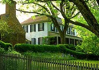
Robert Carter House & Garden

The Colonial Williamsburg's The Revolutionary City is a collection of individual gardens and the cool green spaces that make up the landscape that so many visitors find enchanting. That landscape is a fusion of the simple Baroque town plan imposed on the small hamlet of Middle Plantation by Gov. Nicholson and the remnants of the primordial landscape, a typical Tidewater, Virginia topography of level places and the ravines that mark their drainage.
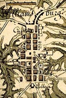
Detail of the 1781 Berthier map of the camp at Williamsburg, Journal 9, no. 39; Louis-Alexandre Berthier Papers. Manuscripts Division, Princeton University Library
This detail of an 18th-century map, with the College at the bottom and the Capitol at the top, shows the rational grid in which the streets were laid out by Gov. Nicholson and the extent to which the ravines cut their deep paths into the backyards just off Duke of Gloucester street in the center. Parts of Nicholson St. to the north were not completely leveled until the late 19th century. What appears to be a two dimensional plan is in reality a 3-D, fractal landscape.
This interpenetration of country and city gives The Revolutionary City bucolic pockets of countryside in the midst of what was once the politically charged capital of the largest and most important English colony of the Georgian Age.
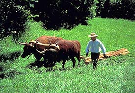
While the city certainly relied on outlying farms and market gardens to provide it with necessities, distances in the Williamsburg area were short, and pasturage, orchards and kitchen gardens in the immediate vicinity supplied the most immediate needs of the city's residents.

Sunset on the James River.

Often overlooked due to the convenience of automobiles and bridges, the topography of Tidewater Virginia is dominated by four major rivers, the Potomac, the Rappahannock, the James and the York, and their tributaries.
Travel in 18th-century Tidewater Virginia was complicated by the near omnipresence of water; but conversely, trade was facilitated by the ease of moving goods via the great rivers.
Many of the great houses of Virginia were placed in order to take advantage of the dramatic views the wide rivers afforded, as here at Carter’s Grove, Carter Burwell’s famous seat situated on a bluff over the James River.