Page content
The Lay of the Land
Possibly the greatest challenge faced by the earliest inhabitants of Williamsburg was how to establish the layout of their town's new streets on the rough terrain of "Middle Plantation," the farming settlement which preceded the creation of the city in 1699. A winding horse path had originally served the dispersed farms and the few public buildings of the Middle Plantation community. This path, which followed the highest ground of the Lower Peninsula, allowed travelers to avoid the still wooded and steep natural ravines that cut through the area.
The preexisting conditions of the Middle Plantation landscape partially dictated the form of the new town's plan. The College of William and Mary and Bruton Parish church had already been built with respect to the horse path's alignment. The plan to locate the Capitol building opposite the College along a principal axis, following the line of a low ridge, dictated a linear approach to the main street. Thus, Governor Francis Nicholson's baroque plan for the new town demanded that three long, straight, east-west streets would have to cross several deep ravines over the length of their intended courses.
One ravine, in particular, was so wide and formidable that Francis Street originally only went as far as the western edge of Market Square until about the turn of this century. The ravine was then partially filled so that Francis Street could link up with France Street to the west, which ran in front of the Public Hospital. These two streets finally became the modern Francis Street of today, now extending the full length of the original town.
Along with the substantial effort necessary to clear vegetation from the ravines where streets would cross them, roadbed construction was also hampered by the presence of water. One reason Middle Plantation had been chosen as the site for the new capital was the plentiful number of freshwater springs in the area. Several were located on public lands and were used by the town's early inhabitants as important sources for drinking water. These springs were located by the Capitol, the Gaol, Market Square, and the Palace. As the town developed, however, it is quite probable that dependence on public springs diminished somewhat as private wells were dug throughout the town.
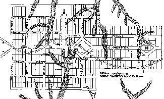
In his fascinating book, Tidewater Towns, historian John Reps advanced several theo-ries concerning the earliest Williamsburg street layout, particularly the contemporary references to streets laid out in a "W and M" cipher by Governor Nicholson. To augment this article, I have taken Reps's conjectural street layout map showing how the town might have initially looked in 1699 and added the location of the old horse path and ravines as they were originally situated. By studying this map one can perhaps better appreciate the difficulty that the Middle Plantation terrain posed in laying out the streets as Nicholson originally intended.
Shortly after Nicholson's recall to England in 1705, changes to his original design were already being considered. In June 1706, the House of Burgesses passed an act to make Duke of Gloucester Street follow a "mathematically streight" course, a supposed reference to correct the conjectural separation in the street's course as it entered Market Square and to prevent any future attempts to fancifully alter the layout of the streets.
By November 1713, Governor Alexander Spotswood, in a speech to the burgesses, recommended resurveying the streets. The wording he used suggests his main concern was with their horizontal alignment. Some work was subsequently done in 1714-1715, although what was specifically involved at that time is today unknown.
In November 1720, the town's inhabitants also petitioned the Assembly for relief from the "irregularitys of their principal street." From the wording of the surviving documents it seems fairly clear that the major complaint they had was with the vertical alignment of the main street, as it dipped into and out of the several ravines over its course of nearly a mile from end to end.
Today one can only imagine just how difficult it must have been, especially in rainy weather, to drive a team of horses pulling a heavily loaded wagon up and down the then hilly slopes of Duke of Gloucester Street. The House of Burgesses no doubt sympathized with the citizens' complaints, as they subsequently appropriated a sum of £150 "towards making Bridges and Causeways in the Main Street," and appointed several trustees to oversee the work and expenditures.
In 1722, Hugh Jones recorded that the money "was expended in removing earth in some places, and building a bridge over a low channel; so that it is now a pleasant, long dry walk, broad, and almost level from the College to the Capitol." At the later Printing Office and Greenhow's Store sites, brick retaining walls were built to hold back the soil. In the ravine where the Printing Office was later located, an extensive, enclosed brick culvert was also built to drain rainwater under the street. Archaeological excavations revealed that on the south side of the street the original grade of this ravine was seven and one half feet below today's sidewalk elevation (at the Mary Stith Shop). The original grade in the ravine on the north side of the street was about twelve feet below today's sidewalk elevation (between the Printing Office and Hunter's Store).
The street repairs ran over the established budget and were not completely finished. The end result of all this work still did not satisfy some citizens, and another petition seeking more money to complete the project was submitted. Their request was quickly denied. Several concerned citizens then suggested levying a tax on all landowners in the town to pay for the remaining work to be done. This bill was soon dropped, however, when Williamsburg was formally incorporated as a city.
The 1720 street filling initiative was an incredibly ambitious and labor-intensive project for its day, and it largely corrected the major problems with the ravines, at least on Duke of Gloucester Street. Without a doubt, it was one of the most significant public works events in the city's history, especially as it established the precedent for later alterations to the terrain in other areas of the city.
Naturally occurring organic fill has also altered the original topography of Williamsburg over time. Colonial Williamsburg's archaeologists say that fill accumulates in an area where human occupation has been constant for three hundred years at a rate of approximately eight to twelve inches every one hundred years. Thus, it is not uncommon on Historic Area sites for archaeologists to dig to depths of between eighteen to twenty-four inches before reaching eighteenth-century subsoil layers. Since leaf mold, organic fill, and trash accumulate at different rates and are, in turn, influenced by human manipulation of the ground, these depths will vary slightly from area to area in town.
As Williamsburg grew, clearing and construction activities disturbed more land, which, in turn, also facilitated soil erosion. The duration and degree to which erosion occurred here has also varied over time. For instance, archaeological excavations in the center of the Historic Area revealed startling evidence of the dynamics of soil erosion that occurred in the third quarter of the eighteenth-century. The James Anderson property is situated on what was then the east slope of the still-open portion of a ravine south of Duke of Gloucester Street. So much erosion occurred there during rainstorms that silt runoff was deposited downstream as it drained north toward Queen's Creek. This silt eventually choked the streambed at the Anthony Hay site to the point of changing its course (a process that was also influenced by Hay having built part of his shop over the stream). The extent of these silt deposits was archaeologically determined when the original grade of the streambed at the Hay site was found to be four to eight feet lower than it is today! From Francis to Duke of Gloucester Streets, the southern portion of this ravine and stream channel was completely filled in sometime around 1778-1782, finally stopping the heavy erosion.
As the eighteenth century progressed, additional improvements to the topography and streets continued to be made. In 1761, the streets were again said to be in so "ruinous a condition" that it was "unsafe to pass in the night in any coach or other carriage," and the city was authorized to spend tax revenues as necessary to keep the streets in better repair. At that time the section of Scotland Street east of the Palace was filled over a ravine that once cut across its right of way and into the northwest corner of the Brush-Everard property.
The western segment of the large ravine located behind the Robert Carter House once extended as far southwest as the location of today's Goodwin Building in the Merchant's Square shopping district. The ravine was gradually filled in over the years to its present location just east of Nassau Street. Nassau Street, as we know it, did not extend any farther north than the Timson House (today at the corner of Prince George and Nassau Streets) in the eighteenth-century. In fact, by the late 1920s only a crude dirt path crossed a narrow embankment that had been filled and placed across the ravine there. The path was finally paved and widened to fifteen feet in 1931, and the grade was substantially raised to construct the traffic circle in front of newly completed Matthew Whaley School. In about 1958, the north Nassau Street paving was widened to its current thirty-foot width.
The east end of town near the Capitol was, at one time, very low and swampy, and has seen substantial filling over the course of time. The discovery of a late seventeenth-century drainage ditch on the later site of Shields Tavern confirms this fact. The ditch was apparently dug to drain this low area by channeling rainwater runoff to the northeast across what later became Duke of Gloucester Street. It eventually joined the natural ravine that is still open between the Dora Armistead House site and the Public Records Office. Originally, this ravine was open along its entire course, extending south along the current western edge of Blair Street and ending in what is today the Capitol parking lot. In fact, the difficult original topography forced the relocation of the Capitol building two hundred feet to the east of the location originally planned for it as indicated on the Bland Survey of 1699.
Other topographic improvements were also made in the nineteenth-century and since that time. Among them was the raising of the grade of Nicholson Street at the Anthony Hay site around 1880 to 1900 to cover an underground gas line. The arrival of the railroad in the 1880s, and the addition of Lafayette Street in the late 1930s, required extensive cutting and filling of natural grades along the northern edge of town to support the respective roadbeds. Two major ravines, one to the north and another to the south of the city, were also partially filled in order to build the Colonial Parkway and its vehicular traffic tunnel under the Historic Area, starting in the late 1930s.
Without a doubt, the physical character of today's city of Williamsburg is very different from what it was throughout much of the eighteenth-century, particularly as it existed during the first quarter of that century. Hopefully, the information outlined in this article will provide a firmer historical basis to explain the vast differences in appearance between the Williamsburg we know so well today, and the historical reality of the colonial town of nearly three centuries ago.