
Page content
The Technology of History
Modern science is helping to solve the puzzles of the past
Text by Michael J. Lombardi
Photography by Dave Doody
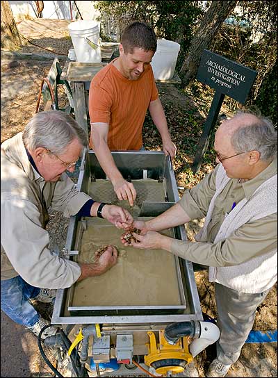
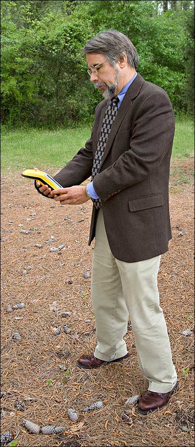
Colonial Williamsburg archaeologist Steve Archer, center, with volunteers Tony Herrmann, left, and Jim Bowers, sift artifacts from a soil sample in a flotation machine to recover bits and pieces of plant material and other information earlier methods missed.
ON HIS BENCH at Colonial Williamsburg, Steve Archer studies a bit of residue rescued from a centuries-old root cellar. In the lab at Monticello, Jillian Galle cautiously removes an artifact from a box of pottery shards, buttons, and nails. In the field at Historic Jamestowne, Bill Kelso searches for evidence about the founders of English America's first colony. As archaeologists have for hundreds of years, they are looking at what the past left behind to discover. What's different is what they're looking at, and where and how they're looking.
Whether it's paleoethnobotany, archaeophysics, dendrochronology, or another exotic specialty, science and technology have opened new doors to the study of long ago. They challenge historians and archeologists to alter the way they search for evidence, to say what constitutes evidence, and decide how to evaluate that evidence.
Archer studies the fragmentary remains of plants. Paleoethnobotany or archeobotany helps him determine how humans and plants interacted.
Plants leave remnants, all fragmentary and incomplete. Science has devised ways to study those remains, producing new lines of evidence. Put together enough data sets and you may learn what people ate and what fuel they burned, and begin to understand the broader picture of changes in their environment.
One line of evidence comes from charred plant remains. A soil sample, obtained from a colonial cooking site, is placed in a flotation machine. The charred plant material floats to the top. Under a microscope, the remains can often be identified. A burnt bit of porridge, corncob, or a piece of potato can tell us something about colonial American foodways.
Another line comes from phytoliths. Plants take up silica from groundwater as they grow. Silica is deposited in the cells and assumes their shapes. When the plant dies and decays or is burned, the silica is left in the soil. The silica remains are called phytoliths. They can be analyzed to identify grasses, wheat, barley, oats, squash, beans, and corn, among other plants.
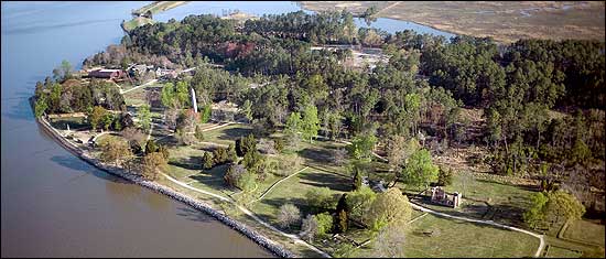
Jamestown Island with the obelisk and site of the original fort on the left side.
The study of plant remains is particularly useful for identifying widespread environmental change. The phytoliths Archer found were in a root cellar deposit at Martin's Hundred, an early 1600s Virginia settlement on a site that became a 1700s plantation. They show that there were radical changes in the landscape in the late seventeenth and early eighteenth centuries as the Virginia colony took root. The earliest phytolith samples indicate a stable assemblage of native Virginia grasses. Later samples show an explosion of European grasses. The phytolith record tells just how quickly the Virginia colonists transformed the land.
Paleoethnobotany offers insights that require a new mind-set for historians. Archer says, "The first archaeologists at Williamsburg were interested in the architecture. Each decade we are refining how we approach archaeological sites. I think we are getting to the point now where we have a discrepancy between what the technologies out there permit us to do and the realities of archaeologists who aren't training in these kinds of scientific approaches."
Making use of these technologies requires training and new procedures. Archer asks, "What happens when you bring artifacts in from a site?"
They get washed. They get scrubbed. With a toothbrush! And all that stuff that's in the vessel potentially has information. A cup of soil may now hold more information, all these microfossils, all these chemical techniques, DNA, than a major excavation.
The residues on artifacts might be used to get some ideas about what the contents of the vessel might have been. Unfortunately, that could be a problem if you stored the artifact in plastic bags, and everything has been stored in plastic bags. One of the things that we try to do, just basic archaeology, is implement a sampling strategy. Save a little bit of the dirt. And maybe it's not in the best bag, but it's better than not having it at all. So, we try to do a systematic collection of everything. Save a little bit of the soil, so we can run a biological sample or we can run a soil chemistry test.
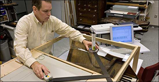
Conservator John Watson of Colonial Williamsburg uses a laser to computer-map a period keyboard instrument.
John Watson, musical instrument conservator at Colonial Williamsburg, has come to appreciate the value of a bit of dust and to see that a speck of paint can reveal more than color:
Take a sample the size of a pinhead. Imbed it in cube of plastic. Slice it through. Polish it and place it under a microscope. Then you use UV light, you use different dyes, you use different reagents that cause different binders and pigments to react in different ways, and you're able to interpret a lot of different things. You can interpret what the pigments are, binders, and certain pigments and binders were not used until a certain time.
Watson restores historic instruments and builds accurate reproductions. These days he often favors leaving old instruments alone. Repairing them could destroy evidence that's hidden in their dirt and scars:
If this is like a crime scene, and if there is history in all these surfaces, and I don't know it all yet, I've got to kind of tiptoe around here because I'm going to disturb evidence. This is a primary document, the only one in the world that has recorded in its surfaces everything that's happened to it for over 200 years. Whatever I do to it, even if I dust it without being careful, I'm erasing pages of a document forever.
When you dig at the site of a historic place, say, Historic Jamestowne, you risk erasing the archaeological context. "Archaeologists say it's a destructive process," says Bill Kelso, the director of archaeology for Preservation Virginia, a program of the Association for the Preservation of Virginia Antiquities. "You've got one shot at digging, and you've got so much information that's taken apart by that process. In the past people couldn't get all that information recorded."
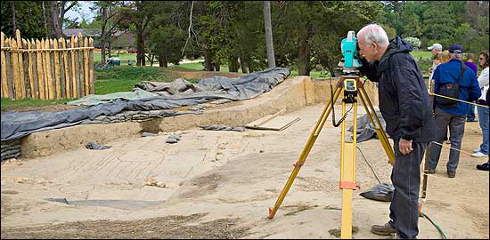
Archaeologist Bill Kelso at Historic Jamestowne uses a laser surveying instrument and a global positioning system to map the dimensions of the 1607 fort.
Now they can, or at least a whole lot more. At Historic Jamestowne, to prepare for the 400th anniversary commemoration in 2007, archaeologists are mapping the triangular fort the first settlers built beside the James River. A laser transit pinpoints locations for a geographic-information-system computer program that creates a nearly three-dimensional view of the site and records where samples or artifacts are found. "It allows you to put so much more data into a retrievable format," Kelso says. "It's transformed archaeology. Instead of trying to look for someone's field notes here, or photographs there, or artifacts that are up in the attic, you can sit at a laptop and you can retrieve all this material, and you can go back to the excavation process and interpret with what you have at your fingertips...The work that we're doing is 100—well, 80—percent better than with pencil and paper."
All that information comes at a price. Computers, laser transits, and custom software cost money, and then there's the memory to store and collate the data, and the system to retrieve it and the people to enter it, and the old computer-age question: What do I do with data from before?
AT MONTICELLO, historians are trying to answer that question. Jillian Galle is project manager for the Digital Archaeological Archive of Comparative Slavery, or DAACS. She asks, "How do we get the hundreds of thousands of artifacts that are stored in boxes across the Chesapeake region into some format that is easy and accessible for researchers and the public? That was the challenge, and we knew that technology could do that."
There are hundreds of thousands of artifacts, each described and catalogued by the archaeologist who collected it. Without a standard entry system, correlations across time and space have been almost impossible. DAACS will change that by creating a standardized database: "The project will bring together archaeological data from twenty slave-quarter sites that have been excavated over the last twenty to twenty-five years. Our goal was to take these collections, bring them to Monticello, and reanalyze all of the artifacts, field records, and maps and to get the information about the field records and the artifacts into a standardized format." The DAACS database will give historians powerful ways of viewing the slave society of the Chesapeake region:
Marley Brown has added a GPS device to his pick and brush to help uncover the buried past.
We can look at old data in a whole new way that was not possible before, and therefore it can tell us stories that could have never been seen with the old data. We couldn't address patterns of consumption, questions about residential units, family formation, particularly when we're dealing with slavery, due to the lack of written sources. How does the slave quarter at Monticello differ from those in the Governor's Palace at Williamsburg, or Mount Vernon, or Poplar Forest? How did diet vary across Tidewater? Can we see differences in African traditions across the sites?
The database has already provided intriguing ideas about how slaves participated in the material culture of the time, but much more needs to be done. So far, Galle and her team have catalogued more than 200,000 artifacts from seventeen sites online and available to historians and scholars at www.daacs.org. But there are hundreds of thousands of Chesapeake region artifacts to be catalogued, and soon Galle and her team will begin tackling material from North and South Carolina, Maryland, and Jamaica.
Archaeologists are becoming familiar with a new range of technology, and they're changing the way they think about sites and samples. Technology gives archaeologists and historians new tools. But it's not the technology that excites the historians; it's the stories that the technology allows them to tell. Marley Brown, director of the archaeology department at Colonial Williamsburg, says, "If you celebrate the technical side of it and say, gee whiz, I can do this because I have a better instrument than you have, you run the risk of straying from the focus, which should be the people in the past and the nature of their lives, and to make sure that focal point is there. The questions have to start with the people, and the interpretation has to end with their lives."
IF YOU'VE WATCHED TELEVISION in the past few years, you've almost surely seen crime-scene investigators using scientific tools to unravel mysteries. In the past decade, historians and archaeologists also have turned to science to help them solve puzzles of the past. Like their television counterparts, history detectives use technology to search for evidence, determine how old the evidence is and what it means. Here are a few of the scientific tools available to probe the mysteries of history.
Where is it?
Archaeophysics. Techniques that help archaeologists find artifacts and survey ancient features without disturbing a site. They include electrical resistance, magnetic field gradient, and ground-penetrating radar surveys; electromagnetic conductivity surveys; total field magnetometry; soil compaction surveys; and laboratory testing of field samples. Each archaeology prospecting tool provides a picture of the underground or underwater features, and by combining them, researchers can gather more-detailed information.
Aerial archaeology. Human activity often leaves marks in the ground that can only be seen from the air. Aerial archaeology uses sophisticated scanners and human observers to discover colors and textures on the ground, shadows, and vegetation patterns left by centuries-old human activity.
How old?
Radiocarbon dating. The basic dating tool is stratigraphy. Simplified dramatically, stratigraphy is based on the premise that things deposited first, the ones deepest in the ground, are oldest. But how old? Radiocarbon dating was invented after World War Two as an outgrowth of the Manhattan Project. Willard Libby and his students and colleagues used the rate of decay—the half-life of carbon 14, which is present in living things—to measure the age of such things as bone, shell, wood, and charcoal. Carbon 14 tests can date objects from 60,000 to 100 years old.
Dating sciences spawned by radiocarbon work include potassium-argon, fission track, obsidian hydration, thermoluminescence, archaeomagnetic, paleomagnetic, oxidized carbon ratios, and electron spin resonance. All measure some physical or chemical property of a sample to determine its age.
Dendrochronology. Everyone knows you can tell how long a tree has been alive by counting its annual growth rings. Dendrochronology takes counting tree rings further by allowing scientists to assign a specific date to a sequence of tree rings. In the early twentieth century, A. E. Douglass at the University of Arizona noted that for certain species of trees wide rings were produced during wet years and narrow rings during dry years.
By studying the sequence of ring patterns in living trees, climate changes in a geographic area can be determined back to the birth of that tree. When the same sequence is found in a tree of unknown age, its rings can be dated, too. If the unknown sample is older than the living sample, dates further into the past can be determined.
In the Southwest, ring samples from long-dead, but still-standing, 4,000-year-old bristlecone trees have been matched with those of living trees. Through overlapping sequences, a bristlecone chronology of nearly 9,000 years has been established and used to date timbers from Pueblo Bonita, a prehistoric Native American settlement in New Mexico, to 700 A.D.
What does it tell us?
Molecular archaeology. Archaeologists have studied pollen, phytoliths, and other plant remains to try to learn what people ate, what they wore, how they changed their environment. Now there is an array of ways—including ceramic petrology, opal phytoliths, quaternary palynology, and neutron activation analysis—to coax secrets from a sample.
The study of deoxyribonucleic acid, or DNA, was used by Historic Jamestowne to try to determine whether bones unearthed at the site belonged to a leader of the 1607 expedition, Bartholomew Gosnold. Archaeologists from Preservation Virginia went to England to obtain DNA from the bones of a Gosnold relative for comparison. The results were inconclusive.
—Michael J. Lombardi
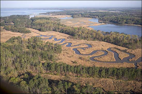
Aerial photography reveals Jamestown Island as a series of sandbars in the James River. Until James Fort was rediscovered in 1996, the site commonly was thought to be underwater.
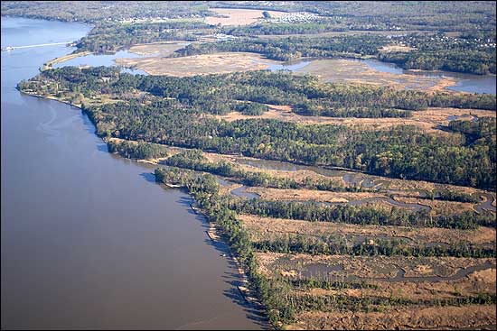
An aerial view of the Back River on 1,500-acre Jamestown Island.
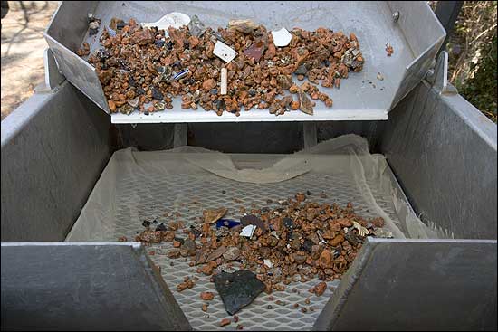
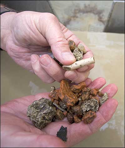
Pebble-sized pieces of brick and shards of pottery are separated from the sediment which preserved them.
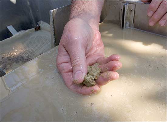
Small artifacts are sifted from silt and mud in this flotation machine.
A small piece of bone is discovered during an excavation.
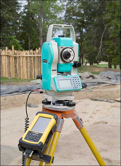
This laser-surveying instrument and Global Positioning System is one of the tools used by archaeologists in the continuing excavation of the site of the first permanent English Settlement in Jamestown, Virginia.
Michael Lombardi is a Williamsburg video and film producer and director. He contributed a story about perpetual motion machines to the winter 2006 journal.